
 by
by 
By Kory White Texas REALTOR® | Avid cyclist riding 100+ miles a week, with 16 years of experience riding DFW and the past 3 years living in both Dallas and Houston
Two flat, sprawling, car-shaped Texas metros. Both hot. Both huge. Both, historically, places where riding a bike was something you loaded into a truck and drove somewhere to do.
But Dallas and Houston have diverged sharply over the last few years. If you are choosing between them, relocating, visiting, or simply wondering how your city compares, the differences matter more than the similarities.
I have spent the past 3 years living in both Dallas and Houston, so this comparison comes from navigating each city as a resident, not simply visiting its most popular trails. This is the guide I wish someone had handed me. It does not stop at naming popular trails. It explains which routes connect, where to begin, where the gaps are, how to use transit with a bicycle, and how to choose a neighborhood that supports the way you actually ride.
The short version
Houston has more bike infrastructure. Dallas has more momentum. I still ride better weeks in Houston.
Dallas’s 2025 Bike Plan counted 89 miles of on-street bikeways and 115 miles of paved off-street linear trails, or about 204 miles combined. Houston has been widely credited with roughly 518 miles of bike lanes, shared lanes, and trails. The numbers are not perfectly apples to apples, but the practical difference is obvious from the saddle: Houston offers more long, uninterrupted off-street mileage today.
Dallas, however, adopted its first major bike-plan update in 14 years in May 2025. The plan is built around an “All Ages and Abilities” standard, and The Loop Dallas is connecting 39 miles of existing trails with 11 miles of new construction to form a 50-mile circuit around the city.
Houston wins if you want long, car-free mileage this weekend. Dallas has the more encouraging development trend.
My personal verdict, and why 16 years of riding DFW pushed me toward Houston rather than away from it, is at the end.
Dallas vs. Houston for cyclists at a glance
| Category | Dallas | Houston |
|---|---|---|
| Existing bike infrastructure | About 204 miles in the 2025 Bike Plan count | About 518 miles across lanes, shared routes, and trails |
| Best off-street network | The Loop Dallas, 50 miles when complete | Bayou Greenways, 150+ miles open |
| Best beginner ride | White Rock Lake | Buffalo Bayou Park |
| Best long-distance corridor | Northaven to White Rock Lake | Brays Bayou Greenway |
| On-street direction | Improving slowly | Mixed, with recent loss of protected infrastructure |
| Bike share | Shared dockless e-bikes available | No citywide bike share since 2024 |
| Terrain | Flat with some rollers and significant wind | Flatter with fewer climbs |
| Biggest summer challenge | High afternoon heat and wind | Heat, humidity, storms, and flooded underpasses |
| Best for | Variety, lake riding, and future connectivity | Continuous mileage and bayou riding |
How to traverse Houston by bicycle
Houston’s trail system is organized around water. Learn the major bayous and the connectors between them, and the city begins to make sense.
The bayous function like bicycle highways. Buffalo Bayou carries riders through the center. White Oak reaches northwest. Brays runs east to west across a large part of the city. Sims serves south Houston. Columbia Tap and the MKT Trail connect those spines to neighborhoods, universities, sports venues, and Downtown.
Houston’s main cycling spines
Buffalo Bayou
Buffalo Bayou Park is the postcard ride. Paved paths follow both sides of the water between Sabine Street and Shepherd Drive, with several bridges allowing riders to change banks and create loops.
It is scenic, central, and easy to understand, but it is also heavily used. Expect runners, walkers, dogs, children, and tourists. It is better for an orientation ride than a high-speed workout.
Best starting point: The Water Works, 105-B Sabine Street
Best for: Visitors, families, casual riders, skyline views
Traffic exposure: Very low inside the park
Important caution: Slow down near bridge approaches, playgrounds, and pedestrian-heavy areas.
White Oak Bayou Greenway
White Oak Bayou is Houston’s northwest cycling artery. Houston Parks Board reports more than 18 miles of public green space and trail within the city limits. The corridor connects parks and neighborhoods including Stude Park, the Heights, T.C. Jester Park, Garden Oaks, Oak Forest, and areas farther northwest.
It also intersects the Heights MKT Trail multiple times and normally connects near the University of Houston-Downtown to Buffalo Bayou.
Major 2026 closure: Beginning January 15, 2026, the Little White Oak Bayou Trail between Houston Avenue and the Leonel J. Castillo Community Center closed for TxDOT’s I-45 and I-10 connector work. TxDOT expects the closure to remain in place through 2028, although intermittent reopening is possible. Follow the posted detour and do not cross construction fencing.
That closure matters because it interrupts the simplest off-street approach between White Oak and Downtown. New riders should download the official detour before leaving rather than trusting an older route saved in a cycling app.
Brays Bayou Greenway
Brays Bayou is the workhorse and the closest thing Houston has to an east-west cycling spine. Houston Parks Board describes it as a 39-mile greenway, with the route serving areas near Mason Park, MacGregor Park, the University of Houston, Hermann Park, Rice University, the Texas Medical Center, Braeswood, Meyerland, and southwest Houston.
For many Texas Medical Center employees, it is Houston’s most practical trail-based commute. It is also the easiest place in either city to build a 30-, 40-, or 50-mile ride without repeatedly circling the same park.
Best central starting point: Hermann Park near South MacGregor Way
Best for: Distance riders, TMC commuters, e-bikes, and riders staying near the Museum District
Traffic exposure: Primarily off-street
Important caution: Bayou underpasses can flood or hold mud and debris after storms.
Sims Bayou Greenway
Sims Bayou is quieter and less crowded than Houston’s central corridors. Nearly 20 miles of trail connect south Houston neighborhoods and green space, with newer park improvements adding more recreational mileage.
It is a useful option for riders relocating to south Houston who want nearby distance without driving to Buffalo or Brays Bayou.
Houston connectors that turn trails into a network
Heights MKT Trail
The Heights Hike-and-Bike Trail, often called the MKT Trail, links the Heights with White Oak Bayou, First Ward, and routes toward Downtown. Its neighborhood access and nearby businesses make it one of Houston’s most practical lifestyle trails.
Columbia Tap Rail-Trail
Columbia Tap runs approximately 4 miles between EaDo and the Brays Bayou area, passing through Third Ward near Texas Southern University and the University of Houston.
This is Houston’s important north-south connector. It allows riders to move between Brays Bayou, EaDo, sports venues, and Downtown-area bikeways without relying entirely on major streets.
Terry Hershey Park and George Bush Park
On Houston’s west side, Terry Hershey Park follows Buffalo Bayou from the Beltway westward and connects toward George Bush Park. Together, the trail systems offer a long suburban ride with limited roadway exposure.
This is the strongest choice for cyclists relocating to Memorial, the Energy Corridor, or west Houston who care more about uninterrupted training mileage than central-city destinations.
Spring Creek Greenway
Spring Creek Greenway provides more than 20 miles of riding in north Harris County near Humble, Kingwood, and surrounding communities. It does not connect directly to Houston’s central bayou system, but it is a major lifestyle asset for cyclists considering the northern suburbs.
Exact Houston routes for your first week
Distances vary based on the entrance, bank, detours, and turnaround point. Treat these as planning ranges and confirm current closures before riding.
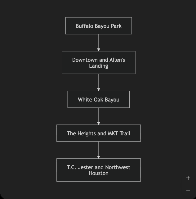
Houston route connection map
The easiest way to understand Houston is to see the bayous as long spines and the neighborhood trails as connectors.
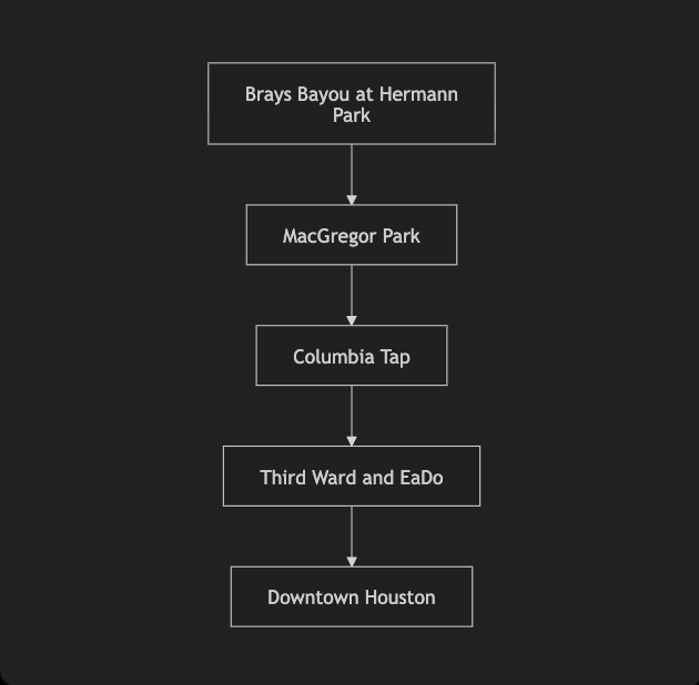
The second major route uses Brays Bayou to reach central universities, Third Ward, EaDo, and Downtown.
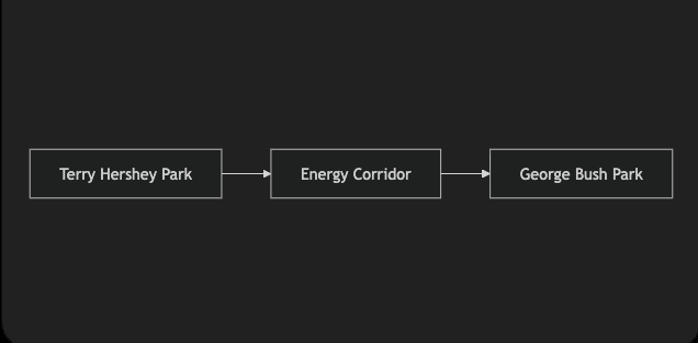
For uninterrupted west-side mileage, follow the Buffalo Bayou corridor away from central Houston.
Route 1: Buffalo Bayou orientation loop
Distance: Approximately 5 to 10 miles
Difficulty: Easy
Start: The Water Works at Sabine Street
- Enter the bayou trail from The Water Works.
- Ride west toward Waugh Drive and Shepherd Drive.
- Cross the bayou on a pedestrian bridge that fits your preferred distance.
- Return east on the opposite bank.
- Finish near Sabine Street and the Downtown skyline.
This is Houston’s best first ride because the navigation is simple, the route is scenic, and the distance is easy to adjust.
Route 2: White Oak Bayou out-and-back
Distance: 10 to 30+ miles
Difficulty: Easy to moderate
Start: Stude Park or T.C. Jester Park
- Enter White Oak Bayou Greenway from the selected park.
- Ride northwest for a longer uninterrupted route, or southeast toward the Heights.
- Turn around at a clearly marked park or street crossing.
- Return on the same corridor.
For a new rider in 2026, an out-and-back north of the Houston Avenue closure is simpler than attempting the White Oak-to-Downtown connection.
Route 3: The Heights neighborhood loop
Distance: Approximately 10 to 15 miles
Difficulty: Easy to moderate
Start: Stude Park
- Enter White Oak Bayou Greenway at Stude Park.
- Connect with the Heights MKT Trail.
- Follow the MKT through the Heights toward Shepherd Drive and the W 26th Street area.
- Use the appropriate MKT-to-White Oak connection to return south.
- Rejoin White Oak Bayou and finish at Stude Park.
Because construction can affect the lower White Oak connection, verify the precise MKT bridge and detour status on the day you ride.
Route 4: Brays Bayou west from Hermann Park
Distance: 10 to 40+ miles
Difficulty: Easy to challenging based on distance
Start: Hermann Park near South MacGregor Way
- Use the marked connection or underpass to enter Brays Bayou Greenway.
- Ride west past the Texas Medical Center and Rice-adjacent areas.
- Continue toward Braeswood, Meyerland, and southwest Houston.
- Choose a turnaround point based on heat, water, and daylight.
- Return east on the same trail.
This is the best Houston route for a rider who wants uncomplicated mileage. A long out-and-back avoids the navigation and street exposure of a city loop.
Route 5: Brays Bayou to EaDo using Columbia Tap
Distance: Approximately 15 to 25 miles depending on the start
Difficulty: Moderate
Start: Hermann Park or MacGregor Park
- Ride east on Brays Bayou toward MacGregor Park.
- Follow signs to the Columbia Tap Rail-Trail connection.
- Turn north on Columbia Tap.
- Continue through Third Ward toward EaDo.
- Reverse the route for the safest beginner-friendly return.
Reaching a specific Downtown restaurant, hotel, or stadium may require an on-street segment. Review that final mile before leaving.
Route 6: Terry Hershey and George Bush Park long ride
Distance: Approximately 20 to 40+ miles
Difficulty: Moderate
Start: A designated Terry Hershey Park trailhead
- Enter the Terry Hershey trail along Buffalo Bayou.
- Ride west through the Energy Corridor.
- Continue into the George Bush Park trail system where the current route allows.
- Turn around at your planned mileage point.
- Return on the same corridor.
This is the west-side answer for riders who want a training route without navigating central Houston.
How to traverse Dallas by bicycle
Dallas has excellent individual trails. The challenge has always been the seams between them.
The city is easiest to understand as 4 clusters: White Rock Lake and East Dallas, Uptown and the Katy Trail, North Dallas and Northaven, and the Trinity River corridor. New connections are beginning to turn those clusters into a more coherent system.
Dallas’s main cycling spines
White Rock Lake
White Rock Lake is the center of gravity for Dallas cycling. The shoreline loop is approximately 9.3 miles and connects with Santa Fe Trail, SoPac, and White Rock Creek Trail.
It is Dallas’s closest equivalent to a cycling town square. On busy mornings, treat it as a shared public trail rather than a racecourse.
Best starting points: Bath House Cultural Center, Winfrey Point, Flag Pole Hill, or Mockingbird Point
Best for: First-time visitors, families, casual riders, and route building
Traffic exposure: Very low once on the loop
Katy Trail
Katy Trail runs approximately 3.5 miles through Uptown toward the Knox area. It is attractive, central, and heavily used.
For cyclists, its value is connectivity rather than speed. The southern end reaches Victory Park and the Hi Line Connector. The northern system reaches toward University Crossing, Mockingbird Station, Ridgewood, SoPac, and White Rock Lake.
Santa Fe Trail
Santa Fe Trail runs from the White Rock Lake area southwest through East Dallas toward Fair Park, Exposition Park, and the edge of Deep Ellum.
This is one of Dallas’s most useful recreational-to-urban connections. It allows a rider to combine the lake with food, entertainment, and central neighborhoods while staying primarily on trail.
SoPac Trail
Dallas Parks lists SoPac at 5.5 miles, connecting White Rock Lake with Santa Fe Trail, Flag Pole Hill, and Ridgewood Trail before reaching Greenville Avenue at Meadow Road.
The trail is a valuable north-south connector, but new riders should not assume every planned northern extension is complete. Follow the current map and trail signs rather than a conceptual future-network map.
White Rock Creek Trail
White Rock Creek Trail extends north from White Rock Lake through a long greenbelt toward North Dallas. It connects into the Low Five area, where Northaven, Cottonwood Creek, White Rock Creek, and the future SoPac connection meet.
Trinity Skyline Trail
The Trinity Skyline Trail provides open views of Downtown from the floodway. Dallas Parks currently lists 11.6 miles of hard-surface trail with connections to Santa Fe Trestle and Coombs Creek.
This route has less shade and more exposure to heat and wind than White Rock Lake. It is better for riders comfortable with isolated sections and changing floodway conditions.
Dallas connectors that make the network work
University Crossing and Ridgewood
University Crossing begins at Glencoe Park and extends nearly 2 miles toward Skillman Street. Its bridge over Mockingbird Lane connects riders with Mockingbird Station, SMU’s East Campus, Ridgewood Trail, and the route between Katy Trail and White Rock Lake.
University Crossing and Ridgewood combine for roughly 3 miles before reaching SoPac. If you memorize one central Dallas connection, make it this one.
Hi Line Connector
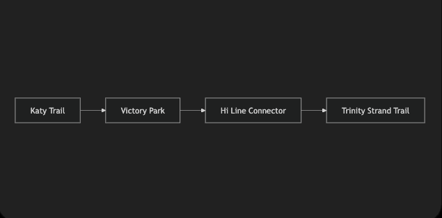
The Hi Line Connector is a 1-mile urban trail linking Katy Trail and Victory Park with the Design District and Trinity Strand Trail. It passes beneath I-35E and active rail lines, solving a gap that once made this trip uncomfortable for many riders.
The Low Five
The Low Five is the trail junction around the Northaven pedestrian bridge over US 75. It brings together Northaven Trail, White Rock Creek Trail, and Cottonwood Creek Trail, with a planned SoPac connection.
Northaven itself runs approximately 8.5 miles east to west. Dedicated bike lanes connect its western terminus at Monroe Drive with the Walnut Hill/Denton Drive DART station.
Cottonwood Creek Trail
Cottonwood Creek connects Richardson-area routes with White Rock Creek and allows riders to move through the High Five interchange separated from regular traffic.
The Loop Dallas
The Loop Dallas is a planned 50-mile circuit joining 39 miles of existing trails with 11 miles of new trail.
It is a major reason Dallas has momentum, but riders should not plan as though the entire ring is open today. The Trinity Forest Spine Trail north phase opened in 2023, and the Hi Line Connector opened in 2024. The Loop’s current schedule targets 2027 for the Discovery Gateway and the Trinity Forest Spine Trail south phase.
When those remaining links open, Dallas will have a continuous circuit that Houston does not currently offer.
Exact Dallas routes for your first week
Dallas route connection map
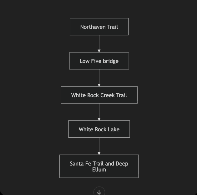
Dallas’s strongest long route begins in North Dallas and follows the connected trail system south toward White Rock Lake and East Dallas.
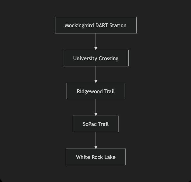
Visitors using DART can reach the White Rock system from Mockingbird Station without beginning in Downtown traffic.
For a shorter urban ride, the southern end of Katy Trail now connects directly toward the Design District.
Route 1: White Rock Lake orientation loop
Distance: Approximately 9.3 miles
Difficulty: Easy to moderate
Start: Bath House Cultural Center
- Enter the shoreline trail near the Bath House.
- Ride the complete loop in either direction.
- Remain on the main lake trail unless intentionally connecting to Santa Fe, SoPac, or White Rock Creek.
- Return to the Bath House.
Save your parking location. The lake has multiple entrances, and different sections can look similar to a first-time visitor.
Route 2: White Rock Lake to Deep Ellum
Distance: Approximately 9 miles out and back on Santa Fe, or roughly 18 to 20 miles when combined with the lake loop
Difficulty: Easy to moderate
Start: White Rock Lake
- Locate the Santa Fe Trail connection on the lake’s west or southwest side.
- Follow Santa Fe southwest through East Dallas.
- Continue toward Fair Park and Exposition Park.
- Leave the trail only after reviewing the final street connection to your Deep Ellum destination.
- Return on Santa Fe, or add the White Rock Lake loop.
This is the simplest Dallas ride that combines recreation, neighborhoods, and an urban destination.
Route 3: Mockingbird Station to White Rock Lake
Distance: Approximately 8 to 15 miles depending on the lake mileage added
Difficulty: Moderate
Start: Mockingbird DART Station
- Exit the station with your bicycle and locate University Crossing.
- Follow University Crossing toward Ridgewood Trail.
- Continue east through Ridgewood.
- Join SoPac.
- Ride south to White Rock Lake.
- Add part or all of the lake loop before returning.
This is the best car-free starting plan for a visitor using DART because it avoids beginning in Downtown traffic.
Route 4: Northaven to White Rock Lake
Distance: 25+ miles depending on the entry point and whether you loop the lake
Difficulty: Moderate to challenging
Start: A Northaven Trail access point
- Ride east on Northaven Trail toward US 75.
- Cross the dedicated pedestrian and bicycle bridge.
- Follow signs at the Low Five toward White Rock Creek Trail.
- Ride south through the greenbelt.
- Arrive at White Rock Lake.
- Complete the lake loop or turn around based on your planned distance.
This is Dallas’s strongest long off-street ride for cyclists living in North Dallas.
Route 5: Katy Trail to the Design District
Distance: Approximately 8 to 12 miles round trip depending on the start and Trinity Strand mileage
Difficulty: Easy to moderate
Start: Katy Trail in Uptown or Victory Park
- Ride south on Katy Trail toward Victory Park.
- Follow Hi Line Connector signs.
- Pass under I-35E and the rail corridor.
- Enter the Design District.
- Continue onto Trinity Strand Trail.
- Return by the same route.
This is an excellent social ride for visitors staying near Uptown, Victory Park, or the American Airlines Center.
Route 6: Trinity Skyline and Santa Fe Trestle
Distance: Adjustable up to approximately 11.6 miles on Trinity Skyline
Difficulty: Moderate
Start: A designated Trinity Skyline or Santa Fe Trestle access point
- Enter the Santa Fe Trestle or Trinity Skyline system from an official access point.
- Follow the floodway trail while tracking your turnaround distance.
- Use extra caution near trail junctions and isolated areas.
- Return before darkness unless you know the corridor well.
Carry water. Shade is limited, wind can make the return much harder, and conditions may change after heavy rain.
If you are visiting without a car
Houston
Stay Downtown, in Midtown, near the Museum District, or along METRORail if cycling is a priority.
A simple first-day plan is Buffalo Bayou Park in the morning, then METRORail toward Hermann Park for an afternoon ride on Brays Bayou. Houston BCycle closed on June 30, 2024, and a replacement citywide bike-share network has not launched, so arrange a rental from a shop before arriving.
METRO allows bicycles on buses and METRORail. Local buses have front racks for 2 bikes. On METRORail, use the first or last door, hold or hook the bicycle, and remember that the system limits trains to 2 bicycles.
Dallas
Stay in Uptown, Victory Park, Deep Ellum, or near a useful DART station.
The simplest no-car itinerary is DART to Mockingbird Station, University Crossing to Ridgewood and SoPac, then White Rock Lake. Another option is Katy Trail to the Hi Line Connector and Design District.
DART permits bicycles on buses, DART Rail, and TRE. Use the low-floor center section of rail vehicles and yield the designated accessible space when needed.
Dallas also permits shared dockless e-bikes, but availability and service areas can vary. Do not build an entire day around finding one at a specific corner.
What navigation apps may not tell you
A green line on a map can represent very different riding conditions:
- A separated multiuse trail
- A protected bicycle lane
- A painted bicycle lane
- Sharrows in mixed traffic
- A sidewalk
- A quiet neighborhood street
- A major road crossing
- A planned trail that is not complete
Before following an unfamiliar route, verify:
- Whether the segment is open today.
- Whether it is off-street or mixed with traffic.
- Whether the final mile requires crossing a frontage road or major arterial.
- Whether construction has changed the detour.
- Whether a bayou underpass is flooded.
- Whether your destination has secure bicycle parking.
- Whether the return remains comfortable after dark.
Download your route before leaving. A saved route is not a substitute for current closure notices or posted signs.
If you are relocating
Do not choose a home because a listing says it is “near a trail.” Choose it because you have tested the actual route from the front door to a usable trail entrance.
Test the first mile
Look for:
- Freeway frontage roads
- Six-lane arterial streets
- Missing sidewalks or curb ramps
- Unprotected left turns
- Railroad crossings
- Flood-prone underpasses
- Poor lighting
- Loose dogs
- School traffic
- Construction detours
A home 0.5 miles from a trail can have terrible bicycle access. Another home 2 miles away may connect through calm residential streets.
Test the route at the time you expect to ride. A street that feels comfortable at 10 a.m. Saturday may be a different environment at 5:30 p.m. Tuesday.
Houston neighborhoods for cyclists
The Heights and Woodland Heights
Best overall combination of White Oak Bayou access, the MKT Trail, a connected street grid, and neighborhood destinations.
Museum District, Rice, and West University
Best for Brays Bayou, Hermann Park, Rice University, METRORail, and the Texas Medical Center.
EaDo and Third Ward
Best for Columbia Tap, central destinations, universities, sports venues, and a more urban riding experience.
Braeswood and Meyerland
Best for direct access to long Brays Bayou rides.
Memorial and the Energy Corridor
Best for Terry Hershey Park and George Bush Park mileage.
Dallas neighborhoods for cyclists
Lakewood, the M Streets, and Lower Greenville
Best for White Rock Lake, Santa Fe Trail, SoPac, and the densest concentration of useful cycling routes in Dallas.
Uptown, Victory Park, and Oak Lawn
Best for Katy Trail, Hi Line Connector, and shorter lifestyle rides near restaurants and entertainment.
Northeast Dallas and Lake Highlands
Best for White Rock Creek, SoPac, Flag Pole Hill, Harry S. Moss Park, and access toward the Low Five.
North Dallas
Best for Northaven, Cottonwood Creek, and longer north-to-south trail rides.
Plano and Frisco
Strong suburban trail systems and calmer residential riding, but many longer road rides still rely on separate suburban networks or farm roads farther north.
Terrain, weather, and season
Both cities are relatively flat, but they do not ride the same.
Dallas has more rolling terrain around White Rock Lake and genuine climbing southwest toward Cedar Hill. The larger factor is wind. Spring days with sustained North Texas wind can turn a flat return leg into a long grind. Winter also produces a handful of genuinely unrideable ice days.
Houston is flatter, and humidity is the main opponent. An early July ride can feel difficult before the temperature peaks because the dew point is already high. The tradeoff is a longer shoulder season and mild winter riding.
Both are sunrise cities from June through September. Start early, carry more water than you think you need, and do not cross moving water or a flooded trail.
On-street riding and the politics behind it
The 2 cities are moving in different directions, although neither story is simple.
Houston has the stronger trail network, but recent decisions have weakened important on-street connections. In 2025, the city removed the concrete protection from the 2-way Austin Street bicycle lane in Midtown. After public opposition, the final design preserved a dedicated lane in one direction, but without physical separation. For riders, that means Austin Street still has bicycle space, but it is not the protected spine it once was.
Dallas is building from a smaller base. The City Council adopted the updated Dallas Bike Plan on May 28, 2025, with an All Ages and Abilities goal and a long-term network. The weakness is speed: the first 5 years call for only a limited portion of the full buildout.
The practical translation is straightforward. Houston offers more good off-street riding now. Dallas is making a stronger current commitment to expand and connect what it has.
The cycling scene
Houston’s cycling culture is larger and more visible. Critical Mass Houston rolls on the last Friday of the month and can attract thousands of riders. Tour de Houston offers multiple route lengths, and the Texas MS 150 shapes the training calendar for riders across the region. Long-running clubs provide structured rides for different speeds and abilities.
Dallas’s scene is more closely associated with its signature trails. The Dallas Bike Ride offers a 20-mile car-free route and finish festival. White Rock Lake functions as a gathering point, Dallas has its own Critical Mass, and trailside businesses show how cycling infrastructure can influence neighborhood culture.
Visitors should check an event organizer’s current page before showing up. Start locations, route lengths, dates, and registration rules can change.
My take
I have ridden DFW for 16 years, everywhere from Frisco to Fort Worth, while logging 100+ miles a week. I have also spent the past 3 years living in both Dallas and Houston, giving me the chance to experience the routes, weather, traffic, and daily realities of each city as a resident. I know the DFW routes as well as anyone. I would still take Houston.
It is not about a simple infrastructure count.
Continuity beats quality. DFW has beautiful trails. What it has lacked is uninterrupted length. Building a 25- or 30-mile Dallas ride often means combining several trails and navigating the seams between them. In Houston, I can point toward Brays Bayou and keep riding. When you are putting in real weekly volume, uninterrupted matters more than pretty.
The good DFW routes are spread across a 40-mile metro. Frisco has trails. Fort Worth has trails. Dallas has trails. Many are not connected to one another, which often means loading the bicycle into a vehicle. Houston’s central bayou routes converge more effectively, so living near one spine can unlock several parts of the city.
The wind changes Dallas riding. North Texas prairie wind can feel like a climb that never ends. Houston humidity is harder during the most oppressive part of summer, but wind affects more of my Dallas riding year.
Houston’s season is longer. Its winters rarely interrupt riding for long.
The honest counterargument is infrastructure policy. Houston’s recent on-street decisions should concern riders, while Dallas is finally connecting its system. If you ride primarily in traffic, or you are choosing based on the next decade rather than next weekend, Dallas deserves serious consideration. When The Loop is complete, it will give the city something distinctive.
But if the question is where I can put more uninterrupted miles under my wheels next Saturday, my answer is Houston.
Final verdict: Dallas or Houston?
Choose Houston if you want:
- Long, flat, off-street mileage
- Bayou greenways
- Fewer route decisions during a long ride
- Mild winter riding
- A larger group-ride culture
- Strong trail access from the Heights, Medical Center, west Houston, or neighborhoods along Brays Bayou
Choose Dallas if you want:
- More terrain and route variety
- White Rock Lake and lake-centered riding
- Better access to mountain-bike options
- Katy Trail and urban lifestyle riding
- A trail system with significant new connections underway
- A future 50-mile circuit when The Loop is completed
For a visitor, begin at White Rock Lake in Dallas or Buffalo Bayou Park in Houston.
For a distance rider, try Northaven to White Rock Lake in Dallas or a Brays Bayou out-and-back in Houston.
For someone relocating, the winner is the city where the right home connects safely to the type of riding you actually do.
The bicycle comparison is only part of a relocation decision. This guide to Dallas vs. Houston cost of living and real estate compares home prices, rent, property taxes, insurance, and the other expenses that affect the monthly budget.
Homebuyers should also understand how the Dallas County homestead exemption compares with the Harris County homestead exemption when estimating long-term ownership costs.
If cycling access matters to your next move, schedule a 15-minute consultation with Kory White. We can compare neighborhoods, actual trail entrances, commute routes, home prices, property taxes, and the complete cost of living in Dallas and Houston.
Either way, ride as if drivers cannot see you. In Texas, that assumption can keep you alive.
About Kory White

Kory White is a Texas REALTOR®, real estate professional, and avid cyclist with more than 20 years of experience helping buyers, sellers, investors, and families make confident real estate decisions across Dallas-Fort Worth, Greater Houston, and other major Texas markets. He rides at least 100 miles a week, has spent 16 years exploring DFW by bicycle from Frisco to Fort Worth, and has lived in both Dallas and Houston during the past 3 years.
Follow My Rides
Want to see the routes I actually ride? Connect with me on Garmin Connect to follow my cycling activity in Dallas, Houston, and across Texas.
You can also watch my 60-mile ride through Dallas for a firsthand look at what cycling through the city is really like.
If you ride in Dallas or Houston, feel free to connect. I’m always interested in discovering new routes and meeting other Texas cyclists.



Join The Discussion